Winnipeg Transit Master Plan
This is the webpage for the Winnipeg Transit Master Plan drafting and engagement process, which took place between 2018 – 2021.
For up-to-date information about the 2025 transition to the Primary Transit Network, visit winnipeg.ca/primarytransitnetwork.
Public engagement on the Winnipeg Transit Master Plan (WTMP) has now concluded. Thank you to all those who provided feedback on the draft plan.
The final Winnipeg Transit Master Plan was adopted by Council on April 29, 2021 as the long-range strategic plan for public transit in the City of Winnipeg.
The plan includes an entirely new transit network to better respond to the needs of residents, with a system that is designed to be resilient, changing and adapting as the city grows. The new network is based on a frequent transit network concept adapted to fit Winnipeg which will more than double the number of Winnipeg households within a short walk of frequent transit service once completed.
Rapid Transit infrastructure expansion serves as the core of the system. The planned Rapid Transit network is comprised of six rapid transit corridors linked together to form three Rapid Transit lines that extend throughout the city. In turn, shorter routes within neighbourhoods will link up to the frequent and rapid transit networks to create an integrated network. The first priority for Rapid Transit is the downtown infrastructure, including an elevated transitway that would establish Union Station as the city’s flagship mobility hub.
The Winnipeg Transit Master Plan also includes changes to Winnipeg Transit Plus to create a more seamless, integrated, and universally accessible network that better integrates conventional transit service with On-Request service and Winnipeg Transit Plus.
- Read the Winnipeg Transit Master Plan
- View the proposed Short Term Network Plan
- View the proposed Long Term Network Plan
- View the proposed 2045 Proposed Rapid Transit Network
With the approval of the Winnipeg Transit Master Plan, Council has also approved six corresponding capital projects. These projects have been put forward for consideration under the Investing in Canada Infrastructure Program (ICIP) and are pending approval by the Provincial and Federal Governments. Other future capital projects resulting from the Master Plan will also be subject to funding and Council approval.
This page was created to assist with public engagement throughout the development of the Winnipeg Transit Master Plan. Following the adoption of the plan by Council, this page is being archived and will no longer be updated.
Updated information about ongoing and upcoming improvements to transit being guided by the Winnipeg Transit Master Plan will be available throughout the Major Projects section of this website.
- Timeline
- Background
- Updates
- Engage
- Documents
- FAQs
- Transit Plus
- Downtown
- Related Links
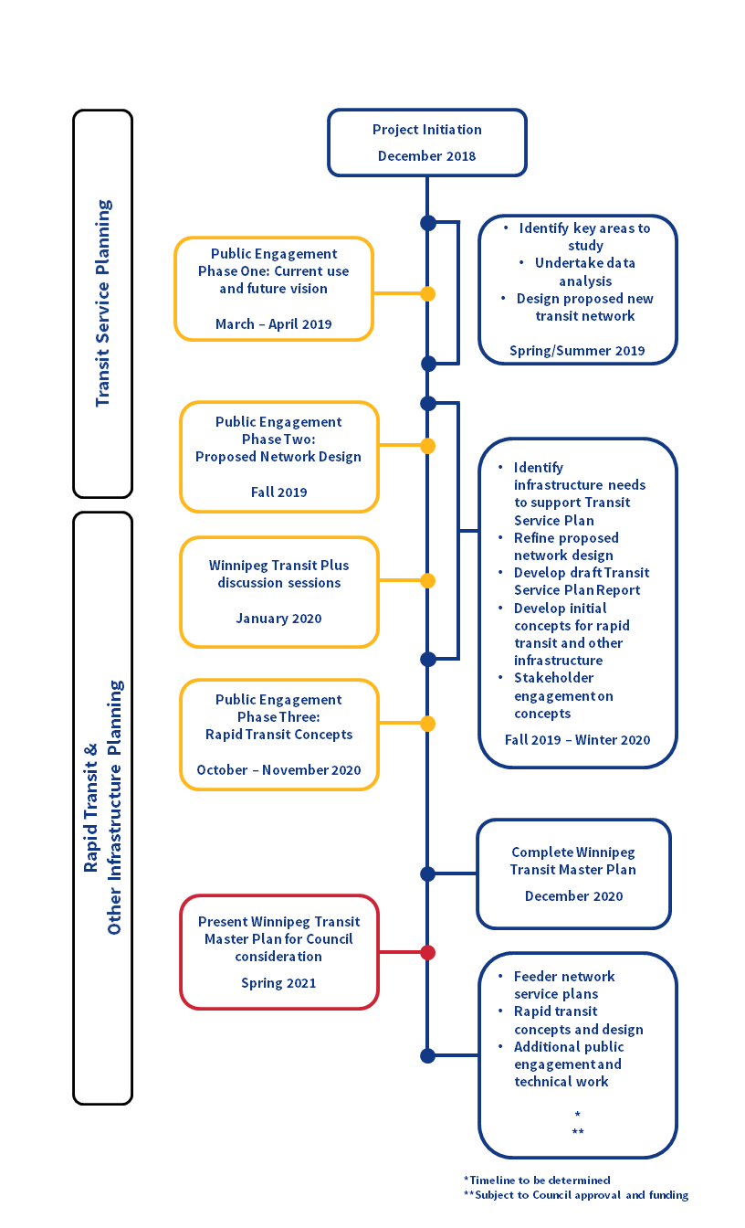
Project Timeline
Background
Winnipeg is growing and our transit system needs to grow too. In the next 25 years, we expect that nearly one million people will call our city home. Now is the time to think ahead about our future transit system. How will we connect people and communities around the city in a sustainable and efficient way?
The proposed Winnipeg Transit Master Plan presents a vision for our future transit system and describes the steps we need to take to get there.
The Winnipeg Transit Master Plan is made up of a number of recommended changes related to network design, routes, and service options. It includes both short and long-term recommendations, with changes in the first five years of the plan more clearly defined and longer-term changes more conceptual. As specific projects and initiatives recommended in the Winnipeg Transit Master Plan move forward, there will be additional opportunities for public input.
The Winnipeg Transit Master Plan is being funded by the City of Winnipeg and the federal government through the federal Public Transit Infrastructure Fund (PTIF). The $3.2 million dollar project is cost-shared 50-50 between the City and federal government.
Updates
Monday, June 14, 2021- The final Winnipeg Transit Master Plan was adopted by Council on April 29, 2021 as the long-range strategic plan for public transit in the City of Winnipeg.
Thank you to everyone who participated in the public engagement process as the plan was developed.
Updated information about ongoing and upcoming improvements to transit being guided by the Winnipeg Transit Master Plan will be available throughout the Major Projects section of this website.
Please note, with the completion of the WTMP, the transitmasterplan@winnipeg.ca email will be retired. Please direct any inquiries to 311@winnipeg.ca.
Tuesday, April 27, 2021- After being endorsed at the Infrastructure Renewal and Public Works (SPC-IRPW) committee meeting held on April 16 and 20, and the Executive Policy Committee (EPC) meeting on April 21, the final Winnipeg Transit Master Plan will now be considered by Winnipeg City Council on Thursday, April 29, 2021.
Monday, April 12, 2021 - After being laid over from the Infrastructure Renewal and Public Works (SPC-IRPW) committee meeting held on Thursday, March 11, 2021, the final Winnipeg Transit Master Plan will now be considered by the SPC-IRPW committee on Friday, April 16, 2021.
If you would like to appear as a delegation, please contact the City Clerk's Department by 4:30 p.m. on Thursday, April 15, 2021.
Thursday, April 1, 2021 - The final plan was presented to the Infrastructure Renewal and Public Works (SPC-IRPW) committee on Thursday, March 11, 2021. As a result of this meeting, the committee laid the matter over to its meeting on April 16, 2021. Notification of the next meeting will be sent to all those on the project updates list once the agenda is available. If you would like to be added to this list, please email us at transitmasterplan@winnipeg.ca.
Friday, March 5, 2021 – Public engagement on the Winnipeg Transit Master Plan has now concluded. Thank you to all those who provided feedback on the draft plan. The final plan will be considered at the Standing Policy Committee on Infrastructure Renewal and Public Works (SPC-IRPW) on Thursday, March 11.
If you would like to appear as a delegation, please contact the City Clerk's Department by 4:30 p.m. on Wednesday, March 10.
November 9, 2020 - Thank you to all those who provided feedback on the draft Winnipeg Transit Master Plan. Online surveys were accepted from Friday, October 9 until Friday, November 6, 2020. We received feedback through 1151 online surveys. Feedback is currently being considered and a summary of the engagement process will be posted online.
October 9, 2020 – Phase Three of public engagement for the Winnipeg Transit Master Plan has begun. In the fall of 2019, we asked for public input on a proposed new transit system. We have included the public’s feedback into the draft Winnipeg Transit Master Plan and are now asking Winnipeggers to share their thoughts on rapid transit and accessibility. To learn more and provide your feedback, please visit the “Engage” tab.
January 15, 2020 – Information sessions with Winnipeg Transit Plus users have concluded. We are reviewing feedback, and will include considerations from these sessions in Phase Three of the Winnipeg Transit Master Plan.
November 26, 2019 – Phase Two of public engagement for the Winnipeg Transit Master Plan has wrapped up. Thank you to all who attended our workshops, community conversations and drop-in events, and to everyone who provided feedback through the online survey or email. Approximately 400 people attended our in-person events, and 3,762 people provided feedback through our online survey.
We are currently reviewing feedback received, and will report back on how this feedback was considered when the plan is presented for Phase Three public engagement in early 2020.
October 25, 2019 – Phase Two of the Winnipeg Transit Master Plan public engagement has begun. We want to hear Winnipeggers’ feedback and input into the proposed network design, including the proposed routes. Your input will inform the draft Winnipeg Transit Master Plan, which we will share with you in early 2020. Please visit the “Engage” tab for more information.
April 23, 2019 – Thank you to all who attended the public events and provided feedback during Phase One of the Transit Master Plan engagement. Feedback is currently being considered and a summary of the engagement process will be posted online. Please visit the Engage tab for more information.
Stay up-to-date on the Winnipeg Transit Master Plan project by signing up for updates: transitmasterplan@winnipeg.ca.
Engage
A multi-phase public engagement approach was taken to gather public and stakeholder feedback on the Winnipeg Transit Master Plan using a range of in-person and online techniques. This allowed the project team to capture public input as the plan evolved and allowed Winnipeggers to choose how they wanted to engage. There were three phases:
- Phase One kicked off the planning process by creating awareness of the project and providing information on current transit patterns and ridership. No plans or proposals were shown at this time, and respondents were simply asked to help describe a vision for Winnipeg's transit system of the future. From March 15 to April 20, 2019, Winnipeggers shared their thoughts on what works and doesn't work well in the current network, and what was important to consider in planning transit for a growing city.
- Phase Two presented the first draft of a proposed new transit network. From October 25 to November 24, 2019, Winnipeggers gave their feedback on the draft route network, proposed service hierarchy, and bus stop and station types. On January 13 and 14, 2020, Winnipeg Transit Plus customers were invited to a series of four sessions to discuss proposed changes to that service.
- Phase Three presented the draft Winnipeg Transit Master Plan between October 24 and 28, 2020, and respondents were asked for input on the proposed rapid transit plan as well as specific follow-up questions on Winnipeg Transit Plus.
The final Winnipeg Transit Master Plan was adopted by Council on April 29, 2021 as the long-range strategic plan for public transit in the City of Winnipeg.
Updated information about ongoing and upcoming improvements to transit being guided by the Winnipeg Transit Master Plan will be available throughout the Major Projects section of this website.
Please note, with the completion of the WTMP, the transitmasterplan@winnipeg.ca email will be retired. Please direct any inquiries to 311@winnipeg.ca.
Documents
FAQs
The Winnipeg Transit Master Plan will lay out a 25-year vision for our transit system and identify the steps we need to take to get there. It will be a long-term, system-wide plan that will cover all aspects of the public transit system – Transit, Rapid Transit, and Transit Plus (formerly Handi-Transit) service and infrastructure.
The Winnipeg Transit Master Plan is being funded by the City of Winnipeg and the federal government through the federal Public Transit Infrastructure Fund (PTIF). The $3.2 million dollar project is cost-shared 50-50 between the City and federal government.
Winnipeg is continuing to grow and is expected to reach nearly a million people in the next 25 years. We need to invest in important services and infrastructure, like public transit, to support a growing, thriving, modern city, now and into the future.
The Winnipeg Transit Master Plan will help ensure that transit can connect people and communities as the city grows. We want to make sure our transit system can provide better options for getting around, make it easier for people to choose and access transit, reduce congestion on our roads, and contribute to a transportation system that serves future generations well.
The Southwest Transitway was developed based on priorities established in Winnipeg’s Transportation Master Plan (adopted 2011). The Winnipeg Transit Master Plan will also be based on the principles of the Transportation Master Plan. Building the Southwest Transitway helped us meet our current transportation needs, while the Winnipeg Transit Master Plan will help us plan for the future. BLUE is the first phase of rapid transit service. Its implementation aligns with the proposed network in the Winnipeg Transit Master Plan.
The Eastern Corridor Study is a separate process that started before the Winnipeg Transit Master Plan, and is being carried out by a different project team. When the Winnipeg Transit Master Plan was announced, the Eastern Corridor Study was placed on hold to ensure alignment between the two projects. The Eastern Corridor Study process has now resumed. Based on the combined analysis of both project teams, we will be recommending a Point Douglas alignment for the rapid transit service to Transcona, as shown in the network maps for the Winnipeg Transit Master Plan. More details on that project will be available from that project team in the near future.
Different areas of the city have different needs for transit. For example, there are usually more riders along major streets and fewer riders in suburban residential areas. The Winnipeg Transit Master Plan uses data showing how Winnipeggers move around the city to propose different service types for different needs and demand. The service types are connected to help people get around the city.
The project team is considering all options. Building light rail infrastructure costs many times more than bus rapid transit infrastructure. To justify the cost, in most cities, the decision to change a rapid line from bus to rail is based on criteria such as how many people use the service now and how many may use the service in the future to justify the cost. The Winnipeg Transit Master Plan will set criteria for when a light rail line should be considered.
The updated Transportation Master Plan will incorporate the recommendations of the Winnipeg Transit Master Plan. The Winnipeg Transit Master Plan will be provided to the project team for the Transportation Master Plan, and the Winnipeg Transit Master Plan and the Transportation Master Plan teams have been working together to help align planning efforts and priorities.
The Winnipeg Transit Master Plan is guided by Winnipeg’s Climate Action Plan, which identifies a strategic opportunity in advancing sustainable transportation. Transportation produces a large amount of pollution and greenhouse gas emissions and the City understands that a sustainable transportation system can help reduce the impact of transportation on the environment. Key directions include increasing the use and efficiency of public transit systems. We know that to meet our goals for reducing emissions, we need to have more people using transit. We want to hear from Winnipeggers about what would encourage them to use transit more and how to design an environmentally sustainable transit system.
The Winnipeg Transit Master Plan is guided by the goals of the Transportation Master Plan (adopted 2011), which include a safe, efficient, and equitable transportation system for people, goods, and services. We also are consulting with organizations that represent low-income Winnipeggers as part of our planning process.
Applications are now being accepted for a new program that provides discounted adult monthly transit passes to eligible families in the City of Winnipeg. Now available for pick up, approved applicants can load their WINNpass with an adult monthly pass that costs 30 percent less than a full fare pass.
Visit the WINNpass page for more information.
The project team will consider how active transportation can work together with the transit system. We also want to hear from Winnipeggers about how the connections between transit and other forms of transportation, including cycling, walking, and automobiles, should be part of a transit system for the future.
The Winnipeg Transit Master Plan is an initiative of the City of Winnipeg and is looking at transit service and infrastructure mostly within the city limits. Transit service for other areas outside of the City is the responsibility of the local municipalities. We recognize that not all transit users currently reside within the city limits and welcome diverse feedback on the plan.
The proposed network design includes seven primary network lines that travel through Portage and Main (all three rapid transit lines and four frequent lines; which can be seen in this map of the full network, including detail of Downtown). We have identified a need to create a transit station at Portage and Main that enables people to make connections between transit lines in a way that is universally accessible while respecting the results of the 2018 plebiscite. This station will be the subject of a separate study that will include further technical analysis and public engagement.
We have also identified alternative routing that would allow us to implement the proposed rapid transit service plan prior to building a new transit station at Portage and Main, if needed. The alternative routes would allow us to implement rapid transit service (high frequency, seven days a week, with limited stops) using existing bus stops (see the Short Term Network Plan for details).
Improving accessibility and integrating Winnipeg Transit Plus are important parts of the Winnipeg Transit Master Plan. To understand the current issues and develop proposed changes, we:
- Reviewed the Manitoba Ombudsman’s report on Winnipeg Transit Plus, the Accessibility for Manitobans Act, and what is being done for accessible transit in other cities
- Held two information sessions with Winnipeg Transit Plus users
- Audited 1,112 bus stops for accessibility based on the City of Winnipeg Accessibility Design Standards
Transit Plus
Accessibility and Winnipeg Transit Plus
In Phase One public engagement, we heard that making transit more accessible to people of all ages and abilities is important to Winnipeggers. In Phase Two public engagement, we also heard from participants who want accessibility to be improved throughout the transit system to make transit more safe and useable for people with disabilities.
Improving accessibility and integrating Winnipeg Transit Plus with conventional transit are important goals of the Winnipeg Transit Master Plan to enable people of all ages and abilities to move around the city. To understand the current issues and develop proposed changes, we:
- Reviewed the Manitoba Ombudsman’s report on Winnipeg Transit Plus, the Accessibility for Manitobans Act, and what is being done for accessible transit in other cities
- Audited 1,112 bus stops for accessibility based on the City of Winnipeg Accessibility Design Standards
- Held two information sessions with Winnipeg Transit Plus users
Based on this information, we are proposing the following changes to Winnipeg Transit Plus and the rest of the transit system to enable people with disabilities to access and use transit with greater convenience, flexibility, and safety:
- Update Winnipeg Transit Plus policies to bring them in line with the Accessibility for Manitobans Act and best practices for accessible transit
- Identify places where two or more transit routes meet, and people are likely to transfer, and prioritize these for accessibility improvements to be completed with other transit infrastructure projects
- Pilot an option for some customers to use Winnipeg Transit Plus and conventional transit together—providing more freedom and flexibility to these customers, and enabling Winnipeg Transit Plus to serve more customers overall
Places where people connect within the transit network will be priorities for accessibility
One of the key steps to make our transit network more accessible is to ensure that places where people connect to transit are accessible. In the proposed network, there will be four types of places where people can connect to transit: stops, junctions, stations, and hubs.
| What are they? | |
|---|---|
| Stops | Marked locations along primary network lines and feeder network routes where riders can access transit. These are used in our current transit system. |
| Junctions | Places where two or more routes meet. Over time, junctions will be developed to make sure they are accessible and to make it easier to change buses. Junctions will also have shelters and real-time transit information. |
| Stations | Places where many people are getting on and off of the bus, usually with two or more connecting lines or routes (for example, a frequent line and a connector route). Stations will be developed with larger shelters, real-time transit information and may have places to change to other kinds of transportation (for example, bike racks or drop-off zones). |
| Hubs | Places where you can transfer between three or more lines or routes and switch between different kinds of transportation – walking, cycling, driving, and public transit. Hubs can also include features like Wi-Fi, food service, and shops. |
The Winnipeg Transit Master Plan commits to making transit junctions, stations, and hubs fully accessible. This includes making sure that:
- Transit stops on opposite sides of the street are near each other—this allows you to start and end your trip near the same place
- Transit stops are near crosswalks at intersections
- Sidewalks connect to the transit stops at junctions, stations, and hubs
- Sidewalks, crosswalks, traffic lights, and curbs are universally accessible
- The distance to walk or roll between transit routes is as short as possible
- There are heated shelters and real-time transit information available
- New stations and all other infrastructure improvements follow the City of Winnipeg Accessibility Design Standards
Winnipeg Transit will work with other City departments to make these improvements, including with Public Works to review signal timing.
As part of the Winnipeg Transit Master Plan, 1,112 bus stops throughout the city were audited based on the City of Winnipeg Accessibility Design Standards. Every stop received a score between 0 and 100 percent. About one-third of stops (378) scored as “good,” meaning they are generally accessible to people with visual, cognitive, and physical disabilities. Ninety-six stops (about eight percent) failed, meaning they are not accessible and it is difficult to get on and off the bus safely.
The results of this audit will be used in two ways:
- Transit stops with “good” scores can be part of a pilot project for some Winnipeg Transit Plus customers to use a combination of Winnipeg Transit Plus and conventional transit to travel around the city
- Locations with a low score that will become transit junctions, stations, or hubs in the proposed network will be prioritized for accessibility improvements when other infrastructure improvements are being made (see the draft plan for rapid transit infrastructure diagram for proposed infrastructure programs and priorities)
Integrating Winnipeg Transit Plus with the conventional network
By making conventional transit more accessible, we can provide more travel options for people with disabilities. One of these options is to combine Winnipeg Transit Plus service and conventional transit for customers whose abilities allow it, providing them more freedom and flexibility.
In this option, a Winnipeg Transit Plus vehicle brings customers from their home to an accessible transit junction, or from an accessible transit junction to their destination, or both. Winnipeg Transit Plus staff will have the information and training they need to help customers plan combined trips. Winnipeg Transit also will provide travel training resources to assist customers in making combined trips door to door.
Before piloting this option, we will make sure the following infrastructure and support is in place:
- Accessible transit junctions, stations, and hubs – locations where customers can easily walk or roll to connect to conventional transit, as detailed above in “Places where people connect within the transit network will be priorities for accessibility”
- Accessible buses – currently, all of Winnipeg Transit’s buses are low-floor, with audible next stop announcements and a visual display of next stops. As buses are replaced, new vehicles will include updated wheelchair securement systems. Winnipeg Transit will also improve signage and public education about priority seating areas to encourage riders to make sure these areas are available for those who need them.
- Accessible destinations – Winnipeg Transit Plus will identify and track destinations that can be reached by an accessible path from rapid transit stations and hubs.
- Trip planning system and eligibility criteria – Winnipeg Transit Plus will upgrade its scheduling system to include information about accessible transit junctions, stations, and hubs and accessible destinations. The eligibility criteria for Winnipeg Transit Plus will also be updated to identify customers who are able to use both conventional transit and Winnipeg Transit Plus. Winnipeg Transit Plus staff will be able to help customers plan trips that use Winnipeg Transit Plus and the conventional system, connecting to the conventional system at accessible locations.
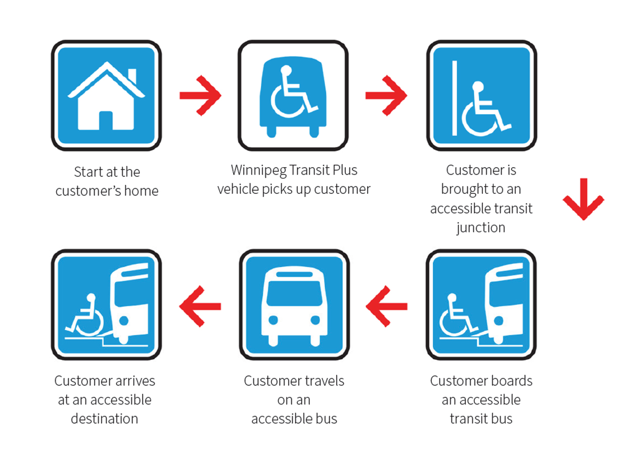
Here is how a trip using both Winnipeg Transit Plus and conventional transit could work:
- Winnipeg Transit Plus vehicle picks up customer at home and transports them to an accessible rapid transit station on Line A (the BLUE rapid transit line).
- Customer boards an accessible bus on Line A. The average wait time is three to five minutes during the day. Rapid transit buses run every five minutes during peak times and every 10 minutes at off-peak times.
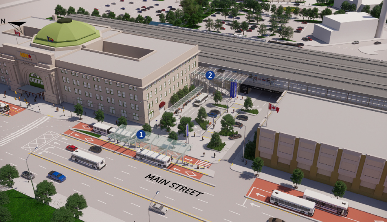
- Customer disembarks at Union Station and proceeds to accessible pick-up/drop-off zone. (See draft concept below.)
- Winnipeg Transit Plus vehicle picks up customer to take them to their final destination Downtown.
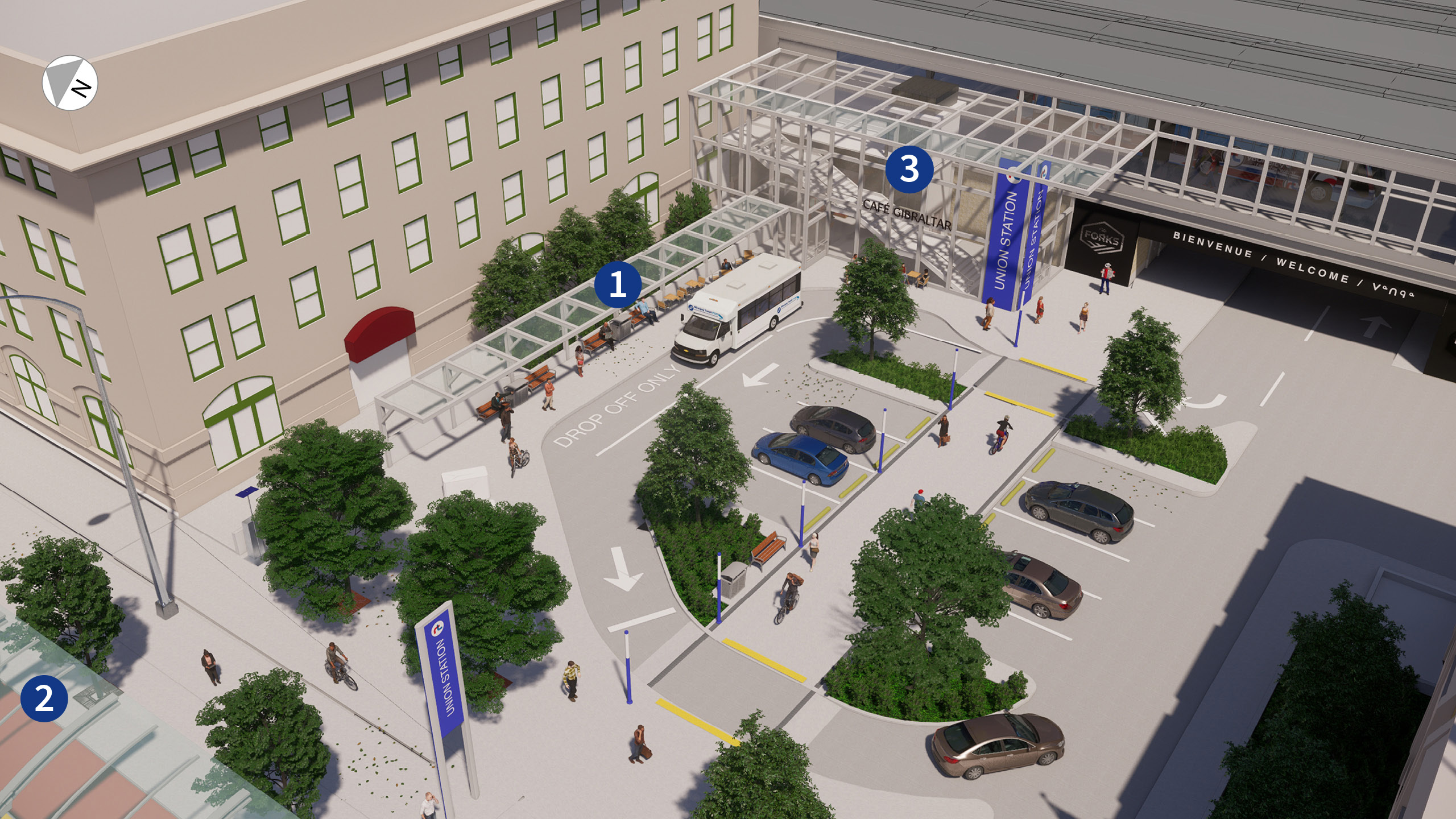
1. Pick-up/drop-off zone 2. Transit station for lines B, Q, and T on Main Street 3. Transit station for lines A, C, and D on elevated transitway, accessible by stairs and an elevator
Downtown
All three rapid transit lines will meet on Main Street between Portage Avenue and Stradbrook Avenue. The renderings below show concepts of how this could look. These concepts will require more detailed design and study before anything is built.
All new transit stations will be built to the City of Winnipeg Accessibility Design Standards, to make transit more accessible for people of all ages and abilities.
Union Station will be the central hub of the rapid transit network. All three rapid transit lines (A, B, and C) and five other frequent and direct lines (D, K, L, Q, and T) will meet at Union Station (click here to see the map of all rapid, frequent, and direct lines). The different lines will be routed through three locations:
1. In front of Union Station at street level on Main Street (B, Q, and T) 2. Inside Union Station on an elevated transitway (A, C, and D) 3. Behind Union Station at street level on Israel Asper Way (K and L, not shown)
The proposed plans for Union Station include improvements for accessibility. The pedestrian crossing at Broadway and Main Street will be improved and there will be better pedestrian access to The Forks.
There will also be new and improved bike paths to connect Union Station to The Forks.
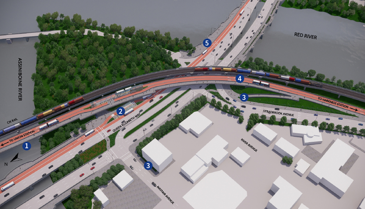
Several changes are proposed at the intersection of Queen Elizabeth Way, Mayfair Avenue, and Stradbrook Avenue:
1. An elevated transitway will run from Union Station to Harkness Station (next to Stradbrook Avenue). 2. There will be a transit station on the east side of the intersection, at both street level and on the elevated transitway, with access between levels via an elevator, escalator, ramps, and stairs. 3. Stradbrook Avenue will become a one-way street (eastbound), and Mayfair Avenue will change directions to connect westbound traffic from Queen Elizabeth Way to River Avenue. 4. A bridge will carry pedestrians and bicycles across the street, to the station, and beyond. 5. The north sidewalk and bike lanes of the Norwood Bridge will be reconfigured. Bicycles and pedestrians will still have access in both directions, on both sides of the bridge.
The proposed network design includes seven primary network lines that travel through Portage and Main (all three rapid transit lines and four frequent lines; see a map of the full network here, including detail of Downtown). We have identified a need to create a transit station at Portage and Main that enables people to make connections between transit lines in a way that is universally accessible while respecting the results of the 2018 plebiscite. This station will be the subject of a separate study that will include further technical analysis and public engagement.
We have also identified alternative routing that would allow us to implement the proposed rapid transit service plan prior to building a new transit station at Portage and Main, if needed. The alternative routes would allow us to implement rapid transit service (high frequency, seven days a week, with limited stops) using existing bus stops (see the short-term network plan for details).
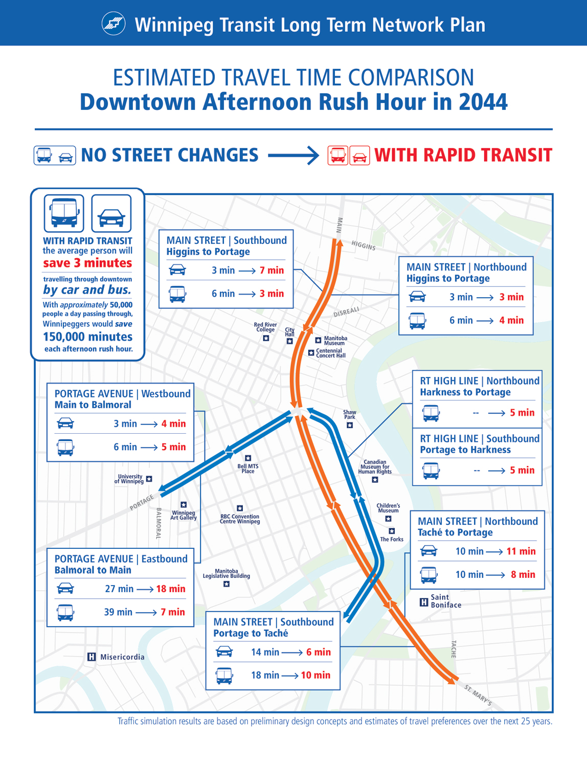
Building fully separated transitways Downtown will help transit move faster, making it more efficient and reliable. With buses removed from traffic, other vehicles will move a little faster too, even with less space.
The graphic below compares estimated travel times Downtown during the afternoon rush hour in 2044 with no street changes to estimated travel times with rapid transit. With rapid transit, the average person will save three minutes travelling through Downtown by car and bus. Approximately 50,000 people will travel through Downtown each day, resulting in a total time savings of 150,000 minutes just during afternoon rush hour.